Potential for tornadoes, all modes of weather tonight, tomorrow
Published 1:55 pm Tuesday, April 9, 2024

- (Metro Creative Services)
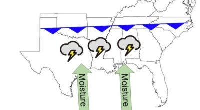
There is potential for strong tornadoes and all modes of severe weather tonight and Wednesday morning through mid-afternoon, said Storm Warning Coordinator Doug Cramer.
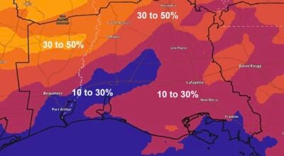
Lake Charles is facing a 15 to 20 percent risk for damaging winds and large hail, and a five to nine percent risk for tornadoes, according to the U.S. National Weather Service Lake Charles Office.
The majority of Calcasieu Parish is at enhanced risk for damaging wind gusts over 58 mph, hail 1 inch in diameter or larger, frequent lightning, flash flooding and tornadoes from early morning into mid-afternoon.
The severe weather with the highest risk in Lake Charles is damaging winds, sitting at 30 to 40 percent.
There is a moderate risk of severe thunderstorms passing through Lake Charles until mid-afternoon on Wednesday, around 2 p.m. The time range with the most concentrated risk in areas along and northwest of La. 165 is 3 a.m. to 12 p.m.
For areas southeast of La. 165 the range of most concentrated risk is 5 p.m. to 3 p.m.
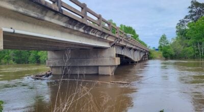
There is also a moderate risk of excessive rainfall, with the area facing the highest risk being West Central Louisiana north of the Highway 190 corridor. In Lake Charles, the predicted level of rainfall is one to one and a half inches. Most of the rainfall is predicted to occur on Tuesday, with showers and thunderstorms tapering off into Wednesday.
A flood watch has been put into effect for Central and Northern Louisiana, including Allen, Beauregard and Vernon parishes, until 7 p.m. on Wednesday.
Cramer said that despite storms over the next 48 hours, the weather on Thursday, April 11, through Sunday, April 14, is expected to be sunny and mild. He also said that the chances favor warmer and wetter than normal conditions in mid-April.