REMEMBERING LAURA: Today marks the third anniversary of her landfall
Published 9:05 am Sunday, August 27, 2023
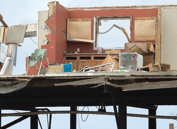
- A raised waterfront residential structure is gutted after Laura’s landfall in Cameron Parish on Aug. 27, 2020. (American Press Archives)
Today marks three years since Laura made landfall near Cameron at 1 a.m. August 27, 2020, as a strong Category 4 hurricane with 150 mph winds.
According to NOAA’s historical database, Laura was Southwest Louisiana’s first Category 4 landfalling hurricane on record.
Laura came ashore at near peak intensity. Measured by windspeed, it was the 10th-strongest U.S. hurricane on record to made landfall.
How it all began
According to the National Weather Service, Laura began August 16, 2020 as a large tropical wave that emerged off the west coast of Africa.
On August 19, the system was upgraded and named Tropical Depression 13.
On August 21, the depression strengthened into Tropical Storm Laura.
On August 25, Laura entered the Gulf of Mexico and became a Category 1 hurricane. Laura began to explosively intensify on August 26, reaching Category 2 by 1 a.m., Category 3 by 7 a.m. and Category 4 by 1 p.m.
Laura reached a peak intensity of 150 mph and a minimum central pressure of 937 millibars (27.67 inches) by 7 p.m.
Laura was the strongest hurricane to strike Southwest Louisiana since records began in 1851, according to the National Weather Service.
(Note: While Laura was a stronger storm at the time of landfall, a Category 4 storm with maximum sustained winds of 150 mph, both hurricanes Rita and Katrina, which hit Louisiana in 2005, were larger and stronger storms over the course of their durations.)
The eye and eyewall of Laura passed over the entire Lake Charles metropolitan area including Lake Charles, Sulphur, Westlake, Moss Bluff and DeQuincy while Laura was still a very powerful Category 4 hurricane.
Laura maintained major hurricane status throughout its passage across Cameron, Calcasieu and southern Beauregard parishes, and Category 2 status across northern Beauregard and Vernon parishes.
Laura finally weakened below hurricane strength by noon as it was crossing I-20 in North Louisiana.
Wind damage to buildings and trees and storm surge damage was major-to-catastrophic across Cameron and Calcasieu parishes.
Across Cameron Parish, the highest winds of 153 mph was measured at Holly Beach at 12:33 a.m. August 27 with a pressure of 945.0 millibars (27.91 inches of mercury).
The National Weather Service at Lake Charles,, located at the Lake Charles Regional Airport, recorded a station record highest peak wind gust of 133 mph at 1:42 a.m., just before the automated surface observing system equipment was destroyed. However, the ASOS barometer sensor that was inside the building and remained intact recorded a station record minimum sea level pressure of 956 millibars (28.23 inches) at 2:20 a.m. when the eye of Hurricane Laura passed nearly overhead.
Storm surge was catastrophic across Cameron Parish, especially around Cameron, Creole, and Grand Chenier. Several structures had over 13 feet inundation, with one structure in Creole showing 17.1 feet above ground level.
Six weeks later, at 6 p.m. Oct. 9, 2020, the area was dealt another blow when category 2 Hurricane Delta made landfall near Creole, just 12 miles east of where Hurricane Laura made landfall.