WEATHER UPDATE: Pockets of rapid onset flooding possible
Published 2:24 pm Thursday, July 17, 2025
- (National Weather Service Lake Charles)
Chances still favor pockets of rapid onset flooding associated with the heavy rainfall a tropical disturbance is expected to bring to Louisiana over the next few days.
National Weather Service Lake Charles meteorologist Donald Jones said there is now a 10 percent chance the disturbance — which is slowly moving inland along the Gulf Coast — could develop into a tropical depression. Regardless of development, rainfall of at least 2-4 inches is expected to inundate Southwest Louisiana through Saturday.
A few areas could receive up to 10 inches, he said.
Trending
“Southwest Louisiana has already seen quite a bit of rainfall and we still have two more days to go,” Jones said. “We’re not expecting all-day ran on Saturday, more likely just in the afternoon.”
High rainfall rates moving over the same location for a prolonged period on Friday will increase the risk for flash flooding.
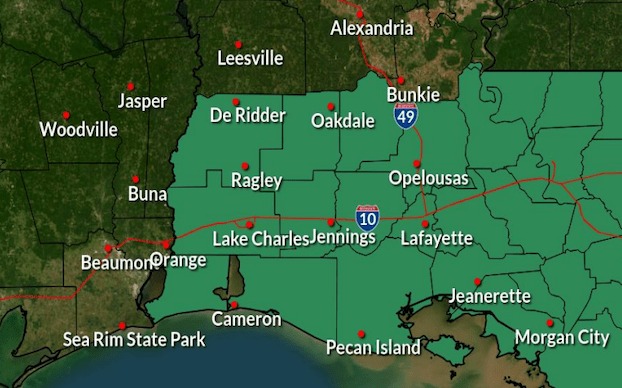
Calcasieu, Cameron, Jeff Davis, Beauregard and Allen parishes have been added to a flash flood watch in effect through 7 p.m. Saturday. Vernon Parish — for now — remains outside the watch zone.
There is no threat of wind threat, tornadoes or storm surges with this system.
Jones said a second area of low pressure is expected next week and appears to be developing along a similar path as this week’s disturbance.
“There could very well be the same scenarios happening next week,” he said.
Trending