Cold front to push through area Wednesday
Published 3:59 pm Tuesday, October 26, 2021
A squall line moving through the region Wednesday afternoon will herald the return of fall — and bringer cooler temperatures with it.
National Weather Service Lake Charles meteorologist Donald Jones said a cold front will follow the squall line — a group of storms arranged in a line — after it moves through the region.
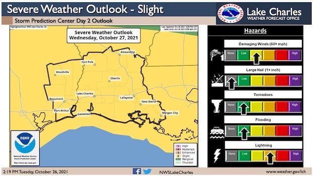
“There’s the possibility of short-lived and isolated severe weather,” Jones said. “The probability of receiving damaging winds is about 15 percent for our region. In addition, there’s a 5 percent chance of seeing an isolated tornado or two.”
He said the squall line is expected to arrive in Southwest Louisiana between noon and 4 p.m.
“This will not be an all-day rain event,” Jones said. “We’re looking at about two hours of rain for each area it passes. We’re not expecting a flood event with this squall line. We will see wind guests at about 30 mph, which is almost tropical storm-force.
“If you’re staying in an RV as the squall moves through, you might want to consider a stronger shelter for about an hour or two, maybe go to the grocery store during that time,” Jones said.
He said those wind gusts could continue through Friday.
“For those who have Halloween decorations outside or on their porch, you might want to consider bringing them in before those ghosts fly off into the night,” he said.
After the squall passes through, daytime temperatures will drop to the low 70s through Halloween with evening temperatures in the upper 40s. He said sunsets will also be happening earlier in the evening, at about 6:30 p.m.